Tag Archives: #mars

The Dust Storms That Dry Up Mars (Planetary Science)

By favoring the release of hydrogen from the atmosphere of Mars, regional dust storms contribute in an important way to the loss of water by the Red Planet: these are the results of the analysis of a Martian dust storm observed in 2019 by the Mars Reconnaissance Orbiter probes. , Trace Gas Orbiter and Maven. Giancarlo Bellucci from INAF also participated in the study

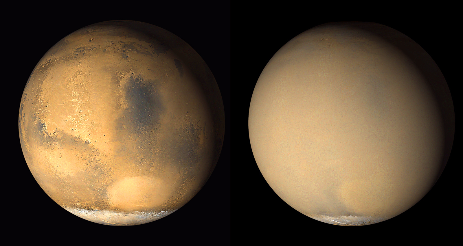
Mars , now an arid and dry planet, has not always been this way: three and a half billion years ago it was quite similar to Earth, with vast oceans of liquid water covering its surface and an atmosphere denser and more humid than it is today. . Some of this water is currently found in the ice caps at the poles or in the planet’s crust, but a significant portion has been lost over billions of years.

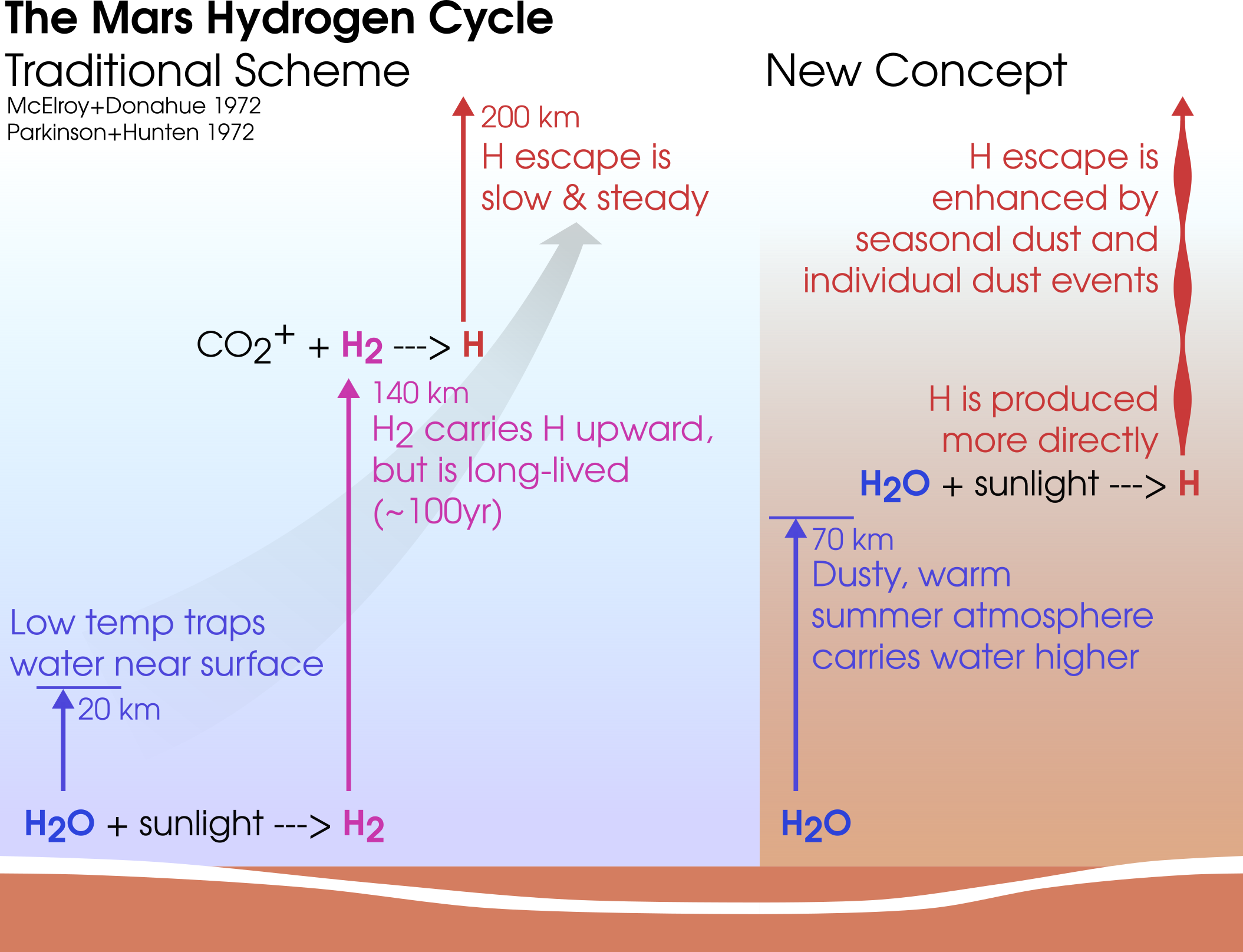
In the 1970s, the Mariner 6 and 7 probes provided the first data to study these ” gas leaks “, which scientists had initially interpreted as a slow and constant phenomenon. However, more recent observations have shown a strong seasonal variability: during the summer, the atmosphere is warmer and water vapor tends to rise more. Above, the atmosphere is more tenuous and the molecules are more vulnerable to ultraviolet radiation from the Sun, which separates the hydrogen atoms from the oxygen ones and favors their escape.

On Mars, however, not all summers are the same: there are peaks of hydrogen loss in the southern hemisphere summer – which occurs near perihelion, the closest point to the Sun along the planet’s orbit – higher than ten to one hundred times the values ​​measured in the northern hemisphere summer. In addition to seasonal variations, the role of dust storms in favoring this process has also been investigated for some time , in particular the global ones that envelop the planet every 1–3 Martian years: the dust heats the atmosphere, triggering similar hydrogen leaks.

A new study, published today in the journal Nature Astronomy , reveals the importance in this balance of a factor largely underestimated until now: the dust storms on a regional scale . Smaller but more frequent than their global counterparts, these short-lived storms would nowadays play a key role in fostering the loss of hydrogen and with it the relentless drying out of the Red Planet. According to the new findings, Mars loses twice the amount of water during a regional dust storm compared to an entire summer season in the southern hemisphere in the absence of regional storms.

Mars in 2001, in two images collected within a month of each other by NASA’s Mars Global Surveyor: the complete blurring produced by the global dust storm is evident in the right pane. Credits: Nasa / Jpl-Caltech / Msss

So far, it was the lack of data that had not allowed researchers to study regional dust storms in detail. That all changed in early 2019, when a more unique than rare coincidence sees the orbits of three space probes around Mars – NASA’s Mars Reconnaissance Orbiter (Mro) and Maven , and ExoMars’ Trace Gas Orbiter (Tgo), a collaboration between ESA and Roscosmos – to line up precisely on the occasion of one of these “fuss”. It was thus possible to observe the region affected by the storm, which unleashed in early January and lasted for several weeks, with four instruments: Mars Climate Sounder on Mro, Imaging Ultraviolet Spectrograph on Maven, and on board the Tgo both Nomad (Nadir and Occultation for Mars Discovery), a Belgian-Spanish-Italian-British-led instrument, whose Italian contribution is financed by the Italian Space Agency, which the Russian-led instrument Acs (Atmospheric Chemistry Suite).

“We really captured the whole system in action,” comments lead author Michael S. Chaffin of the University of Colorado at Boulder.

By combining the data from the four instruments, the researchers were able to measure the temperature and concentration of dust and water ice from the surface up to about one hundred kilometers of altitude with Mro, the concentration of water vapor and ice in the same altitude range with Tgo. , and the quantity of hydrogen – deriving from water vapor molecules “broken” by solar radiation – up to a thousand kilometers of altitude with Maven. In particular, the Nomad instrument aboard Tgo measures with extreme precision the abundance of gases present at various altitudes in the atmosphere of Mars through the solar occultation technique., observing sunlight passing through the atmosphere to measure very small amounts of gas molecules, including water vapor, present at different altitudes.

“In the study published today, Nomad data were used to measure the abundance of water vapor before and during a regional dust storm,” explains Giancarlo Bellucci , INAF researcher in Rome, co-principal investigator of the Nomad instrument and co-principal author of the research.

Together with Acs, Nomad showed the presence of water vapor in the lower atmosphere before the start of the dust storm; then, as it rose, heating the atmosphere and triggering the winds, the instruments revealed the water vapor catapulted to higher altitudes. “It has been seen that the water, due to the dust storm, is pumped from the troposphere up to altitudes of 60 km. At these heights, water molecules are broken up by solar radiation and dispersed into space. Since regional storms are more frequent than global ones, this mechanism can explain how Mars has lost much of its water over time », adds Bellucci.

Traditional (left) and new (right) model of the hydrogen leak from Mars (click to enlarge). Credits: Chaffin et al. 2021

After the storm began, the instruments aboard TGO measured ten times more water in the central part of the central atmosphere. These observations coincide with what MRO detected: the radiometer on board the probe has in fact measured the increase in temperatures in the atmosphere as the dust accumulated above Mars.

“The instruments should all tell the same story, and they do,” points out co-author Geronimo Villanueva of the NASA Goddard Space Flight Center in Greenbelt, Maryland.

MRO also saw the clouds of water ice disappear, as expected as the ice could no longer condense near the surface, which had warmed in the meantime. Further confirmation came from the ultraviolet spectrograph images aboard Maven: the ice clouds, visible before the storm over the volcanoes in the Martian region of Tharsis and completely disappeared during the storm, reappeared soon after. Maven’s observations also captured an aurora in the upper atmosphere accompanied by a fifty percent increase in hydrogen during the storm, reflecting the breakdown of water vapor into hydrogen and oxygen by solar radiation; the increase in hydrogen corresponded to the water measured, a week earlier, at 60 km of altitude,

“This article helps us to virtually go back in time and say,” Okay, now we have another way to lose water that will help us relate the little water we have today on Mars to the huge amount of water we had in the world. past ”», concludes Villanueva.

Featured image: Diagram of the water cycle in the atmosphere of Mars (click to enlarge). Credits: Esa


To know more:

  • Read on Nature Astronomy the article ” Martian Water Loss to Space Enhanced by Regional Dust Storms ” by MS Chaffin, DM Kass, S. Aoki, AA Fedorova, J. Deighan, K. Connour, NG Heavens, A. Kleinböhl, SK Jain , J.-Y. Chaufray, M. Mayyasi, JT Clarke, AIF Stewart, JS Evans, MH Stevens, W E. McClintock, M. Crismani, GM Holsclaw, F. Lefevre, DY Lo, F. Montmessin6, NM Schneider, B. Jakosky, G. Villanueva, G. Liuzzi, F. Daerden, IR Thomas, J.-J. Lopez-Moreno, MR Patel, G. Bellucci, B. Ristic, JT Erwin, AC Vandaele, A. Trokhimovskiy, OI Korablev

Provided by INAF

Geologists Discover That The NASA Rover Has Been Exploring Surface Sediments, Not Lake Deposits For Last Eight Years (Planetary Science)

In 2012, NASA landed the rover Curiosity in the Gale crater on Mars because the crater was thought by many scientists to be the site of an ancient lake on Mars more than 3 billion years ago. Since that time, the rover has been driving along, carrying out geological analyses with its suite of instruments for over 3,190 sols (martian days, equivalent to 3278 earth days). After analysing the data, researchers from Department of Earth Sciences, the Faculty of Science at HKU, have proposed that the sediments measured by the rover during most of the mission did not actually form in a lake.

The researcher team suggested that the large mound of sedimentary rocks explored and analysed for the last eight years actually represent sand and silt deposited as air-fall from the atmosphere and reworked by the wind. The alteration minerals formed by the interaction between water and the sand did not occur in a lake setting. The “wet” environment, they propose, actually represents weathering similar to soil formation under rainfall in an ancient atmosphere that was very different from the present one.

The discovery was published recently in Science Advances in a paper led by research postgraduate student Jiacheng LIU, his advisor Associate Professor Dr Joe MICHALSKI, and co-author Professor Mei Fu ZHOU, all of whom are affiliated with the Department of Earth Sciences. The researchers used chemistry measurements and x-ray diffraction (XRD) measurements, in addition to images of rock textures, to reveal how compositional trends in the rocks relate to geological processes.

“Jiacheng has demonstrated some very important chemical patterns in the rocks, which cannot be explained in the context of a lake environment,” said Dr Michalski. “The key point is that some elements are mobile, or easy to dissolve in water, and some elements are immobile, or in other words, they stay in the rocks. Whether an element is mobile or immobile depends not only on the type of element but also on the properties of the fluid. Was the fluid acidic, saline, oxidising etc. Jiacheng’s results show that immobile elements are correlated with each other, and strongly enriched at higher elevations in the rock profile. This points toward top-down weathering as you see in soils. Further, he shows that iron is depleted as weathering increases, which means that the atmosphere at the time was reducing on ancient Mars, not oxidising like it is on the modern day, rusted planet.”

These images show Gale crater in High Resolution Stereo Camera (HRSC) images, with elevation colorised in blue. The image on the left shows the standard model where Gale crater is generally assumed to have been a large lake (flooded to at least an elevation of ~4,000m). The image at the right is the model proposed by Liu et al., in which only very small, shallow lakes existed on the floor of Gale crater (with the crater flooded only to an elevation of approximately ~4,500m). Most of the sediments were deposited from the atmosphere as air-fall deposits and later weathered from precipitation or ice-melt. A star marks the rover’s landing site. Credit: ESA/HRSC/DLR

Understanding how the Martian atmosphere, and the surface environment as a whole, evolved is important for the exploration for possible life on Mars, as well as our understanding of how Earth may have changed during its early history. “Obviously, studying Mars is extremely difficult, and the integration of creative and technologically advanced methodologies are necessary. Liu and co-authors have made intriguing observations via the utilisation of remote sensing techniques to understand the chemical composition of ancient sediments that inform on their early development. Their data present challenges to existing hypotheses for both the depositional environment of these unique rock formations and the atmospheric conditions that they formed under – specifically, the authors show evidence for weathering processes under a reducing atmosphere in a subareal environment similar to a desert, rather than formation in an aqueous lake environment. Indeed, this work will inspire new and exciting directions for future research.” Assistant Professor from Department of Earth Science Dr Ryan McKenzie added.

China successfully landed its first lander, Zhurong, on Mars in May this year. Zhurong is currently roving the plains of Utopia Planitia, exploring mineralogical and chemical clues to recent climate change. China is also planning a sample return mission likely to occur at the end of this decade.

Featured image: An image taken by the Curiosity Rover MastCam  instrument shows layered sedimentary rocks composing Mount Sharp. The rover has been driving from the floor of Gale crater up through the rocks within these hills in order to understand how the rocks change from lower in the section (older) to higher in the section (younger). The rover have traversed rocks over >400 meters of elevation from the beginning of the mission. Credit: NASA’s Mars Curiosity Rover


Reference: Jiacheng Liu et al, Intense subaerial weathering of eolian sediments in Gale crater, Mars, Science Advances (2021). DOI: 10.1126/sciadv.abh2687


Provided by The University of Hong Kong

Mars Bright South Pole Reflections May Be Clay – Not Water (Planetary Science)

Bright reflections observed at Mars’ south pole serve as evidence for water. But, seeing may be deceiving.

After measuring the area’s electrical properties with orbiting, ground-penetrating radar, an international group of scientists now say that reflections of the red planet’s south pole may be smectite, a form of hydrated clay, buried about a mile below the surface, according to a July 29 report in the journal Geophysical Research Letters.

The research, led by Isaac B. Smith of York University, Toronto, with major contributions by second author Dan Lalich, research associate in the Cornell Center for Astrophysics and Planetary Science in the College of Arts and Sciences, said the presence of liquid water requires implausible amounts of heat and salt.

“Those bright reflections have been big news over the last few years because they were initially interpreted as liquid water below the ice,” Lalich said. “That interpretation is inconsistent with other observations that imply the ice isn’t warm enough to melt, given what we know about conditions on Mars.”

Even on Earth, Lalich said, it is rare to see subsurface reflections from radar that are brighter than the surface reflection.

The reflection is about a mile below the planet’s surface, where “you don’t expect as bright of a reflection,” he said. “We were getting radar reflections that were much brighter than the surface. And that’s really weird. It’s not something that we had really seen before and it’s not something we expected.”

The group had pored over data from the MARSIS (Mars Advanced Radar for Subsurface and Ionosphere Sounding) instrument – a radar that examines the Martian subsurface with a 130-foot antenna via the European Space Agency’s Mars Express orbiter. The MARSIS instrument, jointly developed by the Italian Space Agency and NASA’s Jet Propulsion Laboratory, can probe the planet to a depth of three miles.

Lalich and the other scientists used a diagnostic physical property in ground-penetrating radar called dielectric permittivity, which measures the ability to store electric energy. The group used the reflection strength to estimate the permittivity difference between the ice and the base of the polar cap, and then compared that estimate to lab measurements of smectite.

“Smectites are very abundant on Mars, covering about half the planet, especially in the Southern Hemisphere,” said York University’s Smith. “That knowledge, along with the radar properties of smectites at cryogenic temperatures, points to them being the most likely explanation to the riddle.”

Lalich said the data to confirm the hydrated clay was easily reproduced from the observed data, meaning that liquid water is not necessary to generate bright reflections. The scientists were hoping to find lakes and other geologic forms.

“Unfortunately, that’s a bit of a downer,” he said, “because lakes below the ice cap would have been very exciting. We believe the smectite hypothesis is more likely and it’s more consistent with other observations.”

In addition to Smith and Lalich, the co-authors on “A Solid Interpretation of Bright Radar Reflectors Under the Mars South Polar Ice,” are Craig Rezza, graduate student, York University; Briony Horgan, associate professor, Purdue University; Jennifer L. Whitten, assistant professor, Tulane University; and Stefano Nerozzi, postdoctoral research associate and Jack Holt, professor, University of Arizona.

Featured image: Mars’ south pole – which looks like creamy swirls in cappuccino – is an icy cap with carbon dioxide and other geologic traits.  About a mile below the cap is smectite, a hydrated version of clay. © ESA/Mars Express


Reference:  I. B. Smith et al, A Solid Interpretation of Bright Radar Reflectors Under the Mars South Polar Ice, Geophysical Research Letters (2021). DOI: 10.1029/2021GL093618


Provided by Cornell University

Earthly Rocks Point Way To Water Hidden on Mars (Planetary Science)

 A combination of a once-debunked 19th-century identification of a water-carrying iron mineral and the fact that these rocks are extremely common on Earth, suggests the existence of a substantial water reservoir on Mars, according to a team of geoscientists.

“One of my student’s experiments was to crystalize hematite,” said Peter J. Heaney, professor of geosciences, Penn State. “She came up with an iron-poor compound, so I went to Google Scholar and found two papers from the 1840s where German mineralogists, using wet chemistry, proposed iron-poor versions of hematite that contained water.”

In 1844, Rudolf Hermann named his mineral turgite and in 1847 August Breithaupt named his hydrohematite. According to Heaney, in 1920, other mineralogists, using the then newly developed X-ray diffraction technique, declared these two papers incorrect. But the nascent technique was too primitive to see the difference between hematite and hydrohematite.

Video: Hydrohematite: Water containing hydrohematite on Earth and on Mars EARTH & MINERAL SCIENCES, PENN STATE

Si Athena Chen, Heaney’s doctoral student in geosciences, began by acquiring a variety of old samples of what had been labeled as containing water. Heaney and Chen obtained a small piece of Breithaupt’s original sample, a sample labeled as turgite from the Smithsonian Institution, and, surprisingly, five samples that were in Penn State’s own Frederick Augustus Genth collection.

After multiple examinations using a variety of instruments including infrared spectroscopy and synchrotron X-ray diffraction, a more sensitive, refined method than used in the mid-19th century, Chen showed that these minerals were indeed light on iron and had hydroxyl — a hydrogen and oxygen group — substituted for some of the iron atoms. The hydroxyl in the mineral is stored water.

The researchers recently proposed in the journal Geology “that hydrohematite is common in low-temperature occurrences of iron oxide on Earth, and by extension it may inventory large quantities of water in apparently arid planetary environments, such as the surface of Mars.”

lump of rock with dark red streaks and the original German label
The specimen of hydrohematite discovered by German mineralogist August Breithaupt in 1843 with its original label. IMAGE: ANDREAS MASSANEK, TU BERGAKADEMIE, FREIBERG, GERMANY

“I was trying to see what were the natural conditions to form iron oxides,” said Chen. “What were the necessary temperatures and pH to crystallize these hydrous phases and could I figure out a way to synthesize them.”

She found that at temperatures lower than 300 degrees Fahrenheit, in a watery, alkaline environment the hydrohematite can precipitate out, forming sedimentary layers.

“Much of Mars’ surface apparently originated when the surface was wetter and iron oxides precipitated from that water,” said Heaney. “But the existence of hydrohematite on Mars is still speculative.”

The “blueberries” found in 2004 by NASA’s Opportunity rover are hematite. Although the latest Mars rovers do have X-ray diffraction devices to identify hematite, they are not sophisticated enough to differentiate between hematite and hydrohematite.

“On Earth, these spherical structures are hydrohematite, so it seems reasonable to me to speculate that the bright red pebbles on Mars are hydrohematite,” said Heaney.

The researchers note that anhydrous hematite — lacking water — and hydrohematite — containing water — are two different colors, with hydrohematite being redder or containing dark red streaks.

Chen’s experiments found that naturally occurring hydrohematite contained 3.6% to 7.8% by weight of water and that goethite contained about 10% by weight of water. Depending on the amount of hydrated iron minerals found on Mars, the researchers believe there could be a substantial water reserve there.

Mars is called the red planet because of its color, which comes from iron compounds in the Martian dirt. According to the researchers, the presence of hydrohematite on Mars would provide additional evidence that Mars was once a watery planet, and water is the one compound necessary for all life forms on Earth.

view of Martian landscape, redish brown dirt with occasional rocks showing the tire tracks from the rover
The Red Planet as photographed by the Martian rover Curiosity.  IMAGE: NASA/JPL-CALTECH/MSSS

Other researchers involved in this project include Jeffrey E. Post, mineralogist and curator in charge of gems and minerals, Smithsonian Institution; Timothy B. Fischer, Chevron, Houston; Peter J. Eng, research professor, Consortium for Advanced Radiation Sources and the James Franck Institute, University of Chicago; and Joanne E. Stubbs, research associate professor, Consortium for Advanced Radiation Sources, University of Chicago.

The National Science Foundation and the U.S. Department of Energy supported this research.

Featured image: Hydrohematite (right) is a brighter red than anhydrous hematite (left).Image: Si Athena Chen, Penn State


Reference: Si Athena Chen et al, Superhydrous hematite and goethite: A potential water reservoir in the red dust of Mars?, Geology (2021). DOI: 10.1130/G48929.1


Provided by Penn State

Researchers Measured Red Planet’s Crust, Core and Mantle Using Seismic Data (Planetary Science)

Researchers at ETH Zurich working together with an international team have been able to use seismic data to look inside Mars for the first time. They measured the crust, mantle and core and narrowed down their composition. The three resulting articles are being published together as a cover story in the journal Science.

Since early 2019, researchers have been recording and analysing marsquakes as part of the InSight mission. This relies on a seismometer whose data acquisition and control electronics were developed at ETH Zurich. Using this data, the researchers have now measured the red planet’s crust, mantle and core – data that will help determine the formation and evolution of Mars and, by extension, the entire solar system.

Mars once completely molten

We know that Earth is made up of shells: a thin crust of light, solid rock surrounds a thick mantle of heavy, viscous rock, which in turn envelopes a core consisting mainly of iron and nickel. Terrestrial planets, including Mars, have been assumed to have a similar structure. “Now seismic data has confirmed that Mars presumably was once completely molten before dividing into the crust, mantle and core we see today, but that these are different from Earth’s,” says Amir Khan, a scientist at the Institute of Geophysics at ETH Zurich and at the Physics Institute at the University of Zurich. Together with his ETH colleague Simon Stähler, he analysed data from NASA’s InSight mission, in which ETH Zurich is participating under the leadership of Professor Domenico Giardini.

No plate tectonics on Mars

The researchers have discovered that the Martian crust under the probe’s landing site near the Martian equator is between 15 and 47 kilometres thick. Such a thin crust must contain a relatively high proportion of radioactive elements, which calls into question previous models of the chemical composition of the entire crust.

Beneath the crust comes the mantle with the lithosphere of more solid rock reaching 400–600 kilometres down – twice as deep as on Earth. This could be because there is now only one continental plate on Mars, in contrast to Earth with its seven large mobile plates. “The thick lithosphere fits well with the model of Mars as a ‘one-​plate planet’,” Khan concludes.

The measurements also show that the Martian mantle is mineralogically similar to Earth’s upper mantle. “In that sense, the Martian mantle is a simpler version of Earth’s mantle.” But the seismology also reveals differences in chemical composition. The Martian mantle, for example, contains more iron than Earth’s. However, theories as to the complexity of the layering of the Martian mantle also depend on the size of the underlying core – and here, too, the researchers have come to new conclusions.

The core is liquid and larger than expected

The Martian core has a radius of about 1,840 kilometres, making it a good 200 kilometres larger than had been assumed 15 years ago, when the InSight mission was planned. The researchers were now able to recalculate the size of the core using seismic waves. “Having determined the radius of the core, we can now calculate its density,” Stähler says.

“If the core radius is large, the density of the core must be relatively low,” he explains: “That means the core must contain a large proportion of lighter elements in addition to iron and nickel.” These include sulphur, oxygen, carbon and hydrogen, and make up an unexpectedly large proportion. The researchers conclude that the composition of the entire planet is not yet fully understood. Nonetheless, the current investigations confirm that the core is liquid – as suspected – even if Mars no longer has a magnetic field.

Reaching the goal with different waveforms

The researchers obtained the new results by analysing various seismic waves generated by marsquakes. “We could already see different waves in the InSight data, so we knew how far away from the lander these quake epicentres were on Mars,” Giardini says. To be able to say something about a planet’s inner structure calls for quake waves that are reflected at or below the surface or at the core. Now, for the first time, researchers have succeeded in observing and analysing such waves on Mars.

“The InSight mission was a unique opportunity to capture this data,” Giardini says. The data stream will end in a year when the lander’s solar cells are no longer able to produce enough power. “But we’re far from finished analysing all the data – Mars still presents us with many mysteries, most notably whether it formed at the same time and from the same material as our Earth.” It is especially important to understand how the internal dynamics of Mars led it to lose its active magnetic field and all surface water. “This will give us an idea of whether and how these processes might be occurring on our planet,” Giardini explains. “That’s our reason why we are on Mars, to study its anatomy.”

Featured image: Using seismic data, researchers have now measured the red planet’s crust, mantle and core (Graphic: Chris Bickel/Science, Data: InSight Mars SEIS Data Service (2019). Reprinted with permission from AAAS)


References

(1) Khan A et al.: Upper mantle structure of Mars from InSight seismic data. Science, 373, (6553) p. 434-438. doi: 10.1126/science.abf2966 (2) Stähler S et al.: Seismic detection of the Martian core. Science, 373, (6553) p. 443-448. doi: 10.1126/science.abi7730 (3) Knapmeyer-Endrun B et al.: Thickness and structure of the Martian crust from InSight seismic data. Science, 373, (6553) p. 438-443. doi: 10.1126/science.abf8966


Provided by UTH Zurich

Martian Global Dust Storm Ended Winter Early in the South (Planetary Science)

A dust storm that engulfed the entire Red Planet in 2018 destroyed a vortex of cold air around the Martian south pole and brought an early spring to the hemisphere. By contrast, the storm caused only minor distortions to the polar vortex in the northern hemisphere and no dramatic seasonal changes. Dr Paul Streeter of The Open University’s Faculty of Science, Technology, Engineering and Mathematics will present the work today (23 July) at the virtual National Astronomy Meeting (NAM 2021).

Over two weeks at the beginning of June 2018, localised dust storms combined and spread to form an impenetrable blanket of dust that hid almost the entire planet’s surface. The global dust storm, which coincided with Mars’s equinox and lasted until mid-September, proved fatal to NASA’s solar-powered Opportunity rover.

Streeter and colleagues from The Open University, NASA and the Russian Academy of Sciences examined the effects of the event on the Martian atmosphere by combining data from a Mars Global Climate Model with observations from the European Space Agency’s ExoMars Trace Gas Orbiter and NASA’s Mars Reconnaissance Orbiter missions.

Video: Side-by-side movies show how the 2018 global dust storm enveloped the Red Planet, courtesy of the Mars Color Imager (MARCI) camera onboard NASA’s Mars Reconnaissance Orbiter (MRO).
Credit: NASA / JPL-Caltech / MSSS

Streeter says: “This was a perfect opportunity to investigate how global dust storms impact the atmosphere at the Martian poles, which are surrounded by powerful jets of wind in winter. Since the last global storm in 2007, several new missions and instruments have arrived in Mars orbit, so the 2018 event was the most-observed to date.”

Previous research has shown that high levels of dust in the atmosphere can have significant effects on polar temperatures and winds. The vortices at the winter poles also affect temperatures and the transport of air, dust, water and chemicals, so their disruption could mean substantial changes in the Martian atmosphere.

The team found that the 2018 storm had profoundly different effects in each hemisphere. At the south pole, where the vortex was almost destroyed, temperatures rose and wind speeds fell dramatically. While the vortex may have already been starting to decay due to the onset of spring, the dust storm appears to have had a decisive effect in ending winter early.

The northern polar vortex, by contrast, remained stable and the onset of autumn followed its usual pattern. However, the normally elliptical northern vortex was changed by the storm to become more symmetrical. The researchers link this to the high dust content in the atmosphere suppressing atmospheric waves caused by the extreme topography in the northern hemisphere, which has volcanoes over twice as tall as Mount Everest and craters as deep as terrestrial mountains.

Streeter adds: “Global dust storms at equinox may enhance transport into the southern pole due to the diminished vortex, while the more robust northern vortex continues to act as an effective barrier. If this pattern for global dust storms holds over the course of the thousands of years that Mars maintains this particular axial tilt, it has implications for how dust is deposited at the north and south poles and our understanding of the planet’s climate history.”

Featured image: Images of Mars under clear conditions (left) and during the 2018 Global Dust Storm (right).NASA / ESA / STScl


Further information

The work appears in: “Asymmetric Impacts on Mars’ Polar Vortices From an Equinoctial Global Dust Storm”, P.M. Streeter et al., JGR Planets 126 (5) (2021) (DOI: 10.1029/2020JE006774)


Provided by Royal Astronomical Society

Meet the Martian Meteorite Hunters (Planetary Science)

A team at the Natural History Museum (NHM), London is paving the way for future rovers to search for meteorites on Mars. The scientists are using the NHM’s extensive meteorite collection to test the spectral instruments destined for the ExoMars rover Rosalind Franklin, and develop tools to identify meteorites on the surface of the red planet. The project is being presented today (23 July) at the virtual National Astronomy Meeting 2021.

The cratered surface of our nearest planetary neighbour has a long and complex history, and searching for rocks amidst more rocks may seem like a futile activity. Despite this, Martian rovers statistically have a significantly higher ‘find per mile’ success rate than dedicated meteorite hunts on Earth: for every kilometre travelled by a Mars rover, approximately one meteorite is found, even though the rovers have not been specifically looking for them up till now.

3D weathered structure, known as a Widmanstätten pattern, on the Richa Meteorite (BM1996, M55 Natural History Museum Collection). © S. Motaghian / Natural History Museum

However, as part of the European Space Agency‘s upcoming ExoMars mission, the next rover – named Rosalind Franklin, after the chemist best known for her pioneering work on DNA – will drill down into the Martian surface to sample the soil, analyse its composition and search for evidence of past or present life buried underground.

Meteorites are important pieces of evidence that can help us understand this story; once a meteorite lands on a planet, it is subjected to the same atmospheric conditions as the rest of the surface. Chemical and physical weathering can provide information on climate weathering rates and water-rock interactions, meteorite sizes and distribution can help to infer information about the density of the atmosphere, and stony meteorites could be a potential delivery mechanism for organic materials to Mars.

Sara Motaghian photographing the Martian meteorite Tissint (BM.2012, M1 Natural History Museum Collection) and lab set up with the Aberystwyth University PanCam Emulator (AUP3), the Hyperspectral camera Counterpart, and VNIR contact spectrometer. © Natasha Almeida / Natural History Museum

“Meteorites act as a witness plate across geological time,” said Sara Motaghian, the PhD student at the NHM and Imperial College London who is carrying out the work. “Generally, the surfaces of Mars we are exploring are incredibly ancient, meaning there have been billions of years for the surface to accumulate these meteorites and lock in information from across Mars’ past.”

The team are looking in particular at the use of multispectral imaging with the PanCam instrument, hoping to be able to highlight features in images that could be associated with meteorites as the rover moves across the surface. They are also investigating the possibility of using pattern recognition techniques to distinguish features such as Widmanstätten patterns, which can be revealed by extreme weathering.

The launch of the ExoMars rover was originally scheduled for 2020, however was delayed until 2022 due to technical issues and growing concerns over the coronavirus pandemic. Once the rover reaches Mars in 2023, the team hope that their work will allow meteorites on the surface to be studied for longer by the Rosalind Franklin rover before it drives on, helping to build a more complete understanding of the Martian surface and its history, if any, of life.

Featured image: False-colour image of the Martian meteorite nicknamed “Block Island.” This image was taken with the panoramic camera of NASA’s Mars Exploration Rover Opportunity on July 28, 2009. The false colour enhances the contrast of different types of soil and meteorite material visible in the image. © NASA


Provided by Royal Astronomical Society

Scientists Determine Mars Crustal Thickness (Planetary Science)

Based on the analysis of marsquakes recorded by NASA’s InSight mission, the structure of Mars’s crust has now been determined in absolute numbers for the first time. Beneath the InSight landing site, the crust is either approximately 20 or 39 kilometers thick. That is the result of an international research team led by geophysicist Dr. Brigitte Knapmeyer-Endrun at the University of Cologne’s Institute of Geology and Mineralogy and Dr. Mark Panning at Jet Propulsion Laboratory, California Institute of Technology (Caltech). InSight stands for “Interior Exploration using Seismic Investigations, Geodesy and Heat Transport.” NASA’s lander, which landed on Mars on 26 November 2018, explores the crust, mantle and core of the red planet. The paper “Thickness and structure of the Martian crust from InSight seismic data’ will appear in Science on July 23.

In the past, only relative differences in the thickness of the Mars crust could be estimated, and additional assumptions were required to obtain absolute thicknesses. The resulting absolute values thus showed large scatter, depending on which assumptions were made. Seismology now replaces these assumptions with a direct measurement at the landing site, and thus calibrates the crustal thickness for the entire planet. This independent data point also allows estimating the density of the crust.

“What seismology can measure are mainly velocity contrasts. These are differences in the propagation velocity of seismic waves in different materials,” said Knapmeyer-Endrun, lead author of the paper. “Very similar to optics, we can observe phenomena like reflection and refraction. Regarding the crust, we also benefit from the fact that crust and mantle are made of different rocks, with a strong velocity jump between them.” Based on these jumps, the crust’s structure can be determined very precisely.

The data show that at the InSight landing site, the top layer is about 8 (+/-2) kilometers thick. Below that, another layer follows to about 20 (+/-5) kilometers. “It is possible that the mantle starts under this layer, which would indicate a surprisingly thin crust, even compared to the continental crust on Earth. Beneath Cologne, for example, the Earth’s crust is about 30 kilometers thick,” Knapmeyer-Endrun explained. Possibly, however, there is a third crustal layer on Mars, which would make the Martian crust under the landing site about 39 (+/-8) kilometers thick. That would be more consistent with previous findings, but the signal from this layer is not essential to match existing data. “In both cases, however, we can rule out the possibility that the entire crust is made of the same material known from surface measurements and from Martian meteorites,” the geophysicist said. “Rather, the data suggest that the uppermost layer is composed of an unexpectedly porous rock. Also, there could be other rock types at greater depths than the basalts seen at the surface.”

Mars: Scientists determine crustal thickness
This artist’s rendering shows a cutaway of the Seismic Experiment for Interior Structure instrument, or SEIS, which will fly as part of NASA’s Mars InSight lander. SEIS is a highly sensitive seismometer that will be used to detect marsquakes from the Red Planet’s surface for the first time.There are two layers in this cutaway. The outer layer is the Wind and Thermal Shield – a covering that protects the seismometer from the Martian environment. The wind on Mars, as well as extreme temperature changes, could affect the highly sensitive instrument. The inside layer is SEIS itself, a brass-colored dome that houses the instrument’s three pendulums. These insides are inside a titanium vacuum chamber to further isolate them from temperature changes on the Martian surface. Credit: NASA/JPL-Caltech/CNES/IPGP

The single, independent measurement of crustal thickness at the InSight landing site is sufficient to map the crust across the entire planet. Measurements from satellites orbiting Mars provide a very clear picture of the planet’s gravity field, allowing the scientists to compare relative differences in crustal thickness to the measurement taken at the landing site. The combination of these data provides an accurate map.

Mars: Scientists determine crustal thickness
This is NASA InSight’s second full selfie on Mars. Since taking its first selfie, the lander has removed its heat probe and seismometer from its deck, placing them on the Martian surface; a thin coating of dust now covers the spacecraft as well. This selfie is a mosaic made up of 14 images taken on March 15 and April 11 – the 106th and 133rd Martian days, or sols, of the mission – by InSight’s Instrument Deployment Camera, located on its robotic arm. Credit: NASA/JPL-Caltech

The crustal thickness of Mars is particularly interesting because the crust formed at an early formation stage from the remnants of a molten mantle. Thus, data on its present-day structure can also provide information on how Mars evolved. In addition, a more precise understanding of the evolution of Mars helps to decipher how early differentiation processes unfolded in the solar system and why Mars, Earth, and other planets are so different today.

Featured image: The two largest quakes detected by NASA’s InSight appear to have originated in a region of Mars called Cerberus Fossae. Scientists previously spotted signs of tectonic activity here, including landslides. This image was taken by the HiRISE camera on NASA’s Mars Reconnaisance Orbiter. Credit: NASA/JPL-Caltech/University of Arizona


Reference: Brigitte Knapmeyer-Endrun et al., “Thickness and structure of the martian crust from InSight seismic data,” Science (2021). vol. 373 no. 6553 438-443. DOI: https://doi.org/10.1126/science.abf8966


Provided by University of Cologne

NASA’s Curiosity Rover Finds Patches of Rock Record Erased, Revealing Clues (Planetary Science)

A new paper enriches scientists’ understanding of where the rock record preserved or destroyed evidence of Mars’ past and possible signs of ancient life.

Today, Mars is a planet of extremes – it’s bitterly cold, has high radiation, and is bone-dry. But billions of years ago, Mars was home to lake systems that could have sustained microbial life. As the planet’s climate changed, one such lake – in Mars’ Gale Crater – slowly dried out. Scientists have new evidence that supersalty water, or brines, seeped deep through the cracks, between grains of soil in the parched lake bottom and altered the clay mineral-rich layers beneath.

Sedimentary Signs of a Martian Lakebed
This evenly layered rock photographed by the Mast Camera (Mastcam) on NASA’s Curiosity Mars Rover shows a pattern typical of a lake-floor sedimentary deposit not far from where flowing water entered a lake. Credit: NASA/JPL-Caltech/MSSS

The findings published in the July 9 edition of the journal Science and led by the team in charge of the Chemistry and Mineralogy, or CheMin, instrument – aboard NASA’s Mars Science Laboratory Curiosity rover – help add to the understanding of where the rock record preserved or destroyed evidence of Mars’ past and possible signs of ancient life.

“We used to think that once these layers of clay minerals formed at the bottom of the lake in Gale Crater, they stayed that way, preserving the moment in time they formed for billions of years,” said Tom Bristow, CheMin principal investigator and lead author of the paper at NASA’s Ames Research Center in California’s Silicon Valley. “But later brines broke down these clay minerals in some places – essentially resetting the rock record.”

Mars: It Goes on Your Permanent Record

Mars has a treasure trove of incredibly ancient rocks and minerals compared with Earth. And with Gale Crater’s undisturbed layers of rocks, scientists knew it would be an excellent site to search for evidence of the planet’s history, and possibly life.

Using CheMin, scientists compared samples taken from two areas about a quarter-mile apart from a layer of mudstone deposited billions of years ago at the bottom of the lake at Gale Crater. Surprisingly, in one area, about half the clay minerals they expected to find were missing. Instead, they found mudstones rich with iron oxides – minerals that give Mars its characteristic rusty red color.

Scientists knew the mudstones sampled were about the same age and started out the same – loaded with clays – in both areas studied. So why then, as Curiosity explored the sedimentary clay deposits along Gale Crater, did patches of clay minerals – and the evidence they preserve – “disappear”?

Clays Hold Clues

Minerals are like a time capsule; they provide a record of what the environment was like at the time they formed. Clay minerals have water in their structure and are evidence that the soils and rocks that contain them came into contact with water at some point.

“Old Soaker”
The network of cracks in this Martian rock slab called “Old Soaker” may have formed from the drying of a mud layer more than 3 billion years ago. Credit: NASA/JPL-Caltech/MSSS

“Since the minerals we find on Mars also form in some locations on Earth, we can use what we know about how they form on Earth to tell us about how salty or acidic the waters on ancient Mars were,” said Liz Rampe, CheMin deputy principal investigator and co-author at NASA’s Johnson Space Center in Houston.

Previous work revealed that while Gale Crater’s lakes were present and even after they dried out, groundwater moved below the surface, dissolving and transporting chemicals. After they were deposited and buried, some mudstone pockets experienced different conditions and processes due to interactions with these waters that changed the mineralogy. This process, known as “diagenesis,” often complicates or erases the soil’s previous history and writes a new one.

Diagenesis creates an underground environment that can support microbial life. In fact, some very unique habitats on Earth – in which microbes thrive – are known as “deep biospheres.”

“These are excellent places to look for evidence of ancient life and gauge habitability,” said John Grotzinger, CheMin co-investigator and co-author at the California Institute of Technology, or Caltech, in Pasadena, California. “Even though diagenesis may erase the signs of life in the original lake, it creates the chemical gradients necessary to support subsurface life, so we are really excited to have discovered this.”

By comparing the details of minerals from both samples, the team concluded that briny water filtering down through overlying sediment layers was responsible for the changes. Unlike the relatively freshwater lake present when the mudstones formed, the salty water is suspected to have come from later lakes that existed within an overall drier environment. Scientists believe these results offer further evidence of the impacts of Mars’ climate change billions of years ago. They also provide more detailed information that is then used to guide the Curiosity rover’s investigations into the history of the Red Planet. This information also will be utilized by NASA’s Mars 2020 Perseverance rover team as they evaluate and select rock samples for eventual return to Earth.

“We’ve learned something very important: There are some parts of the Martian rock record that aren’t so good at preserving evidence of the planet’s past and possible life,” said Ashwin Vasavada, Curiosity project scientist and co-author at NASA’s Jet Propulsion Laboratory in Southern California. “The fortunate thing is we find both close together in Gale Crater, and can use mineralogy to tell which is which.”

Curiosity is in the initial phase of investigating the transition to a “sulfate-bearing unit,” or rocks thought to have formed while Mars’ climate dried out.

The mission is managed by JPL, a division of Caltech, for NASA’s Science Mission Directorate, Washington. Colleagues in NASA’s Astromaterials Research and Exploration Science Division at Johnson and NASA’s Goddard Space Flight Center in Greenbelt, Maryland, also are authors on the paper, as well as other institutions working on Curiosity.

“Knockfarril Hill”
The Mast Camera (Mastcam) on NASA’s Curiosity Mars rover captured this mosaic as it explored the “clay-bearing unit” on Feb. 3, 2019 (Sol 2309). This landscape includes the rocky landmark nicknamed “Knockfarril Hill” (center right) and the edge of Vera Rubin Ridge, which runs along the top of the scene. Credit: NASA/JPL-Caltech/MSSS

Featured image: A self-portrait of NASA’s Curiosity rover taken on Sol 2082 (June 15, 2018). A Martian dust storm has reduced sunlight and visibility at the rover’s location in Gale Crater.


Reference: T. F. Bristow, J. P. Grotzinger, E. B. Rampe, J. Cuadros, S. J. Chipera, G. W. Downs, C. M. Fedo, J. Frydenvang, A. C. McAdam, R. V. Morris, C. N. Achilles, D. F. Blake, N. Castle, P. Craig, D. J. Des Marais, R. T. Downs, R. M. Hazen, D. W. Ming, S. M. Morrison, M. T. Thorpe, A. H. Treiman, V. Tu, D. T. Vaniman, A. S. Yen, R. Gellert, P. R. Mahaffy, R. C. Wiens, A. B. Bryk, K. A. Bennett, V. K. Fox, R. E. Millken, A. A. Fraeman, A. R. Vasavada, “Brine-driven destruction of clay minerals in Gale crater, Mars”, Science  09 Jul 2021: Vol. 373, Issue 6551, pp. 198-204 DOI: 10.1126/science.abg5449


Provided by NASA JPL